


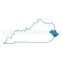
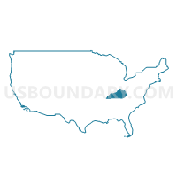
Big Sandy Area Development District PUMA, Kentucky
About
Outline

Summary
| Unique Area Identifier | 192998 |
| Name | Big Sandy Area Development District PUMA |
| State | Kentucky |
| Area (square miles) | 1,988.27 |
| Land Area (square miles) | 1,980.18 |
| Water Area (square miles) | 8.09 |
| % of Land Area | 99.59 |
| % of Water Area | 0.41 |
| Latitude of the Internal Point | 37.60576600 |
| Longtitude of the Internal Point | -82.65592620 |
Maps
Graphs
Select a template below for downloading or customizing gragh for Big Sandy Area Development District PUMA, Kentucky


Neighbors
Neighoring Public Use Microdata Area (by Name) Neighboring Public Use Microdata Area on the Map
- Buffalo Trace & Gateway Area Development Districts PUMA, KY
- Cabell, Wayne & Mason Counties--Huntington City PUMA, WV
- FIVCO Area Development District PUMA, KY
- Kentucky River Area Development District PUMA, KY
- LENOWISCO & Cumberland Plateau Planning District Commissions PUMA, VA
- Logan, Mingo, Wyoming & McDowell Counties PUMA, WV
Top 10 Neighboring County (by Population) Neighboring County on the Map
- Pike County, KY (65,024)
- Wayne County, WV (42,481)
- Wise County, VA (41,452)
- Floyd County, KY (39,451)
- Mingo County, WV (26,839)
- Letcher County, KY (24,519)
- Buchanan County, VA (24,098)
- Johnson County, KY (23,356)
- Knott County, KY (16,346)
- Dickenson County, VA (15,903)
Top 10 Neighboring County Subdivision (by Population) Neighboring County Subdivision on the Map
- Pikeville CCD, Pike County, KY (15,535)
- Paintsville CCD, Johnson County, KY (14,132)
- Prestonsburg CCD, Floyd County, KY (12,772)
- Salyersville CCD, Magoffin County, KY (9,468)
- District 1, Wise County, VA (9,438)
- Stonewall district, Wayne County, WV (8,100)
- Inez CCD, Martin County, KY (8,073)
- Jenkins CCD, Letcher County, KY (7,801)
- South Williamson CCD, Pike County, KY (7,336)
- Martin-Allen CCD, Floyd County, KY (5,448)
Top 10 Neighboring Place (by Population) Neighboring Place on the Map
- Pikeville city, KY (6,903)
- Paintsville city, KY (3,459)
- Prestonsburg city, KY (3,255)
- Williamson city, WV (3,191)
- Salyersville city, KY (1,883)
- Coal Run Village city, KY (1,706)
- Elkhorn City city, KY (982)
- Phelps CDP, KY (893)
- McRoberts CDP, KY (784)
- Wheelwright city, KY (780)
Top 10 Neighboring Unified School District (by Population) Neighboring Unified School District on the Map
- Pike County School District, KY (58,483)
- Wayne County School District, WV (42,481)
- Wise County Public Schools, VA (41,452)
- Floyd County School District, KY (39,451)
- Mingo County School District, WV (26,839)
- Buchanan County Public Schools, VA (24,098)
- Letcher County School District, KY (21,268)
- Johnson County School District, KY (19,495)
- Knott County School District, KY (16,346)
- Dickenson County Public Schools, VA (15,903)
Top 10 Neighboring State Legislative District Lower Chamber (by Population) Neighboring State Legislative District Lower Chamber on the Map
- State House District 2, VA (69,063)
- State House District 3, VA (66,212)
- State House District 94, KY (42,026)
- State House District 99, KY (41,007)
- State House District 92, KY (40,191)
- State House District 97, KY (40,179)
- State House District 71, KY (38,856)
- State House District 93, KY (38,421)
- State House District 95, KY (36,945)
- State House District 91, KY (36,437)
Top 10 Neighboring State Legislative District Upper Chamber (by Population) Neighboring State Legislative District Upper Chamber on the Map
- State Senate District 38, VA (175,805)
- State Senate District 27, KY (110,935)
- State Senate District 31, KY (101,309)
- State Senate District 25, KY (100,866)
- State Senate District 29, KY (94,194)
- State Senate District 6, WV (93,502)
Top 10 Neighboring 111th Congressional District (by Population) Neighboring 111th Congressional District on the Map
- Congressional District 5, KY (670,051)
- Congressional District 9, VA (656,200)
- Congressional District 3, WV (588,817)
Top 10 Neighboring Census Tract (by Population) Neighboring Census Tract on the Map
- Census Tract 9502, Martin County, KY (8,073)
- Census Tract 9210, Floyd County, KY (7,236)
- Census Tract 9604, Johnson County, KY (6,597)
- Census Tract 9702, Magoffin County, KY (6,381)
- Census Tract 9302, Pike County, KY (6,222)
- Census Tract 9208, Floyd County, KY (5,448)
- Census Tract 9504, Morgan County, KY (4,966)
- Census Tract 9502, Letcher County, KY (4,930)
- Census Tract 9204, Floyd County, KY (4,877)
- Census Tract 9203, Floyd County, KY (4,856)
Top 10 Neighboring 5-Digit ZIP Code Tabulation Area (by Population) Neighboring 5-Digit ZIP Code Tabulation Area on the Map
- 41501, KY (23,298)
- 41465, KY (11,979)
- 41230, KY (11,730)
- 41653, KY (11,451)
- 41472, KY (10,985)
- 41339, KY (10,957)
- 24228, VA (7,016)
- 41240, KY (6,916)
- 25661, WV (6,837)
- 41224, KY (6,414)